Hokkaido, Kyushu, Busan, Honshu. October, November, December 2025

Autumn foliage colours in featured photographs in this series have not been enhanced. The autumn colours are truly vivid and spectacular in nature and do not need enhancing. Simply amazing colours!

Odori Park, in SAPPORO. ("important river flowing through a plain" in Ainu language). Sapporo is the capital of HOKKAIDO and Japan's fifth largest city. Sapporo is also one of Japan's youngest major cities. In 1857, the city's population stood at seven people. In the beginning of the Meiji Period, when the development of Hokkaido started on a large scale, Sapporo was chosen as the island's administrative centre. On the top of the photograph above, the ski-jump ramp from the 1972 when the Olympic Winter Games is visible. The Meiji ("enlightened rule") period (1868-1912) was a transformative era in Japan when the country modernized rapidly and transitioned from the feudal Shoju period to a centralized industrial country.

Sapporo experiences heavy snowfall every year; the city has extensive drainage system to cope with melt water.

A very pleasant city; a Sapporo park.

The original Sapporo Beer factory, now containing shops. Sapporo is the birthplace of beer in Japan. Sapporo Beer, one of the oldest beer brands in the Japan, has been brewed in Sapporo since 1877.

OTARU was recognised as a village in 1865. An Imperial decree in July 1899 established Otaru as an open port for trading with the United States and the United Kingdom. The city grew as the financial and business center in Hokkaido and as well as the trade port with Japanese ruled southern Sakhalin until the 1920s. OTARU Canal was a central part of the port in the first half of the 20th century. Large vessels were unloaded by smaller ships, which then transported the goods to warehouses along the canal. The canal became obsolete when modern dock facilities allowed for direct unloading of larger vessels. Thanks to a citizens' movement, a part of the canal was restored in the 1980s. (Wikipedia)

The Nippon Yusen building at the Otaru Canal is a reminder of the prosperity of the city. Completed in 1906 for Nippon Yusen Kaisha (now known as NYK Line), one of Japan’s largest shipping companies. At the time, Japan’s leading architects were designing the city’s buildings; the Nippon Yusen building were designed by Satachi Shichijiro (1856–1922). Satachi was one of the first students of British architect Josiah Conder (1852–1920) at the present-day University of Tokyo. His design shows the Renaissance Revival style, popular in Europe.

Otaru canal warehouse.

The Historic Village of Hokkaido (Kaitaku no Mura) is an open air museum located in the Nopporo Forest Park outside of the suburbs of Sapporo. It exhibits typical buildings from all over Hokkaido, dating from the Meiji and Taisho Periods (1868 to 1926), the era when Hokkaido's development was carried out on a large scale. The museum was opened in 1983.

The autumn colours at the time of our visit to the open air museum were stunning!

AOYAMA's family structures for a herring fishing operation. The Oayama family settled in Otaru in 1859 and operated a herring fishing business there. The family carefully preserved the accommodation, storage rooms and Mr. Kaoru Aoyama donated the structures to the museum.

The family room of the Aoyama family.

Store room for fermented produce in the Aoyama enterprise

This picture shows the herring fishing method as used by the Aoyama enterprise. Herring fishing remained important until the 1950's.
Fishing vessel from the Aoyama family.

AKIYAMA family house. The family moved from the Oga peninsula, Akita Prefecture, to Hokkaido in 1910 and carried on herring fishing until the 1950's. The house is donated by Mr Kiyozi Akiyama.

Akiyama family room.

Hokuseikan Silk-worm House. Built in 1905, a silk-worm house of this type specialised in raising silk-worms and collect eggs to be sold to individual sericulturists. This silk-worm production house was donated by Mr Koichi Tamura.

Hokuseikan Tamura was a sericulture instructor in 1901. Tamura san built a sericulture to produce eggs and technical guidance. He was a teacher at the sericulture training centre.

Hokkaido was home to 8,492 silk farms.

DAISETSUZAN Mountain Range. This photograph is taken from Mount Kurodake (1,984 m).

Mount Kurodake, near the summit.

SHIROGANE Blue Pond. This manmade pond was made to protect Biei town from vulcanic eruptions and flows from Mount Tokachidake. The blue hue is from minerals, such as aluminium, carried from nearby hot springs and reflect sunlight in a unique way.

The Blue Pond is surrounded by larch and birch trees. The deciduous Japanese larch (Larix kaempferi), Karamatsu, is native to Japan and is an important tree in forestry plantations. This larch is also widely distributed in Ireland and Britain. The wood is tough and durable, and is used for general construction work. (Wikipedia)

Betula pendula, the silver birch, European white birch or East Asian white birch, is native to Japan, Siberia, Europe, China, and southwest Asia, in the mountains of northern Turkey, the Caucasus, and northern Iran. It has been introduced into North America, where it is known as the European white birch or weeping birch and is considered invasive in some states in the United States and parts of Canada. (Wikipedia)

East of Sounkyo village in the Daisetzusan Mountain Range there are two waterfalls, Ginga no Taki (Milky Way Falls) and Ryusei no Taki (Shooting Star Falls).

Driving from the Daisetzusan Mountain Range to Muroran via Biratori, one passes through intense and large scale farming areas. In the 1800's in the Meiji period, when Hokkaido was developed, contact between Hokkaido and the North-East of the United States brought large scale farming techniques to Hokkaido. The (green) barn roof style in Hokkaido is a copy from the North-East of America.

MURORAN is an industrial port city in southeastern Hokkaido. Situated between mountains and the Pacific Ocean, Muroran and the surrounding hills offer great views.

Ocean view from the Cape Chikyu near Muroran. We had great light and skies during our visit!

The name Muroran, comes from the Ainu language. Ainu, the indigenous people of northern Japan have their own distinct culture and language. Ainu have lived in Muroran for long but the Matsumae clan, which was in charge of the early Japanese settlements in Hokkaido, took control of Muroran and made a trading post for Japanese-Ainu trade in the 16th century. After Japan annexed Hokkaido, the city was developed into a transportation hub and an international port. In the early 20th century, Japan Steel Works was founded by cooperation of 3 Japanese and British companies and since then the city is known for steel and chemistry industries.

Upopoy (National Ainu Museum and Park). Located on the shores of Lake Poroto. The Ainu are indigenous people from the Northern region of Japan (“Upopoy” translates to “singing together in a large group”). The Ainu originate from the northern parts of the Japanese archipelago, including Hokkaido. The Ainu have their own language, and their own history and ways of life. The Ainu reside in northern Japan and southeastern Russia, the land surrounding the Sea of Okhotsk, such as Sakhalin, the Kuril Islands, the Kamchatka Peninsula, and the Khabarovsk Krai. Official surveys of the known Ainu population in Hokkaido received 11,450 responses in 2023, and the Ainu population in Russia was estimated at 300 in 2021. Unofficial estimates in 2002 placed the total population in Japan at 200,000 or higher, as the population of the Ainu into Japanese society has resulted in many individuals of Ainu descent having no knowledge of their ancestry. The Ainu were subject to forced assimilation during the Japanese colonization of Hokkaido. Japanese assimilation policies in the 19th century around the Meiji Restoration included forcing Ainu peoples off their land. This, forced them to give up traditional ways of life such as subsistence hunting and fishing. Ainu people were not allowed to practice their religion and were placed into Japanese-language schools, where speaking the Hokkaido Ainu language was forbidden. In 1966, there were about 300 native Ainu speakers. In the 1980s, fewer than 100 native Ainu speakers, with only 15 using the language daily. The Hokkaido Ainu language is likely extinct today, as there remain no known native speakers. The other Ainu languages, Sakhalin Ainu and Kuril Ainu were declared extinct in the 20th century. In recent years, there have been increasing efforts to revitalize the Hokkaido Ainu language. (Museum information and Wikipedia)

Ainu fishing. Upopoy museum.

Ainu. Upopoy museum.
Ainu. Upopoy museum.

Upopoy. Located on the shores of Lake Poroto in Shiraoi Town, the Upopoy National Ainu Museum and Park is one of the places where the Ainu culture is well alive today.

Noboribetsu Jigokudani Valley, not far from Muroran, also called the Hell Valley with hot steam vents, sulphurous streams, and hot spring water.

Oyunuma, a sulphurous pond with a surface temperature of 50 degrees Celsius and a smaller, even hotter, mud pond nearby.

Not far from Noboribetsu is Lake Tōya (TOYA-USU UNESCO Global Geopark). It is the northernmost lake in Japan that never ices. The photograph shows Nakajima Island in the middle of the lake.

Ukimido Park on the northern shore of the lake with a view to Nakajima Island.

From Hokkaido, we travelled to KYUSHU, where we hired a car. We had a wonderful stay in Fukuoka and subsequently drove to Nagasaki, Ibusuki on the far south point of Kyushu and Beppu where we had a very relaxing stay and enjoyed the many onsen in the area. The picture above was taken from our hotel room in Ibusuki with a view to the harbour.

Another view from our room. We had a beautiful stay in Ibusuki in a unique hotel. The sea eagle kept following the viewfinder.

This picture was taken not far from our Ibusuki hotel; the district has stunning volcanic plugs and intensive horticulture on the very fertile soils. This field is adjacent the coast.

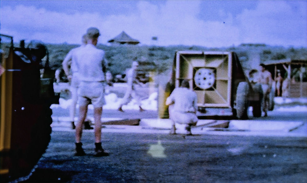
The CHIRAN PEACE MUSEUM, near Ibusuki, is dedicated to the second world war kamikaze - "kami" (divine) and "kaze" (wind) - operations. The kamikaze operation, a last resort flight of a fighter aircraft equipped with a bomb weighing 250 kg attempted to ram and sink an enemy ship. The Chiran Airbase dates back to 1941 when it was established as a flight training school for young air cadets. By 1945, as Japan faced imminent defeat the base's two runways became the launch point for kamikaze missions targeting the US fleet near Okinawa. Of the 1,036 army aviators who perished in these attacks, 439 took off from Chiran, making it the principal base for kamikaze operations during the Battle of Okinawa. These pilots were also known as "tokko" (special attack) units. The strategy of using suicide attacks was implemented by Admiral Takijiro Onishi in 1944 as a desperate measure to protect Japan from US invasion. The museum details of the sorties of the 1,036 Army airmen who died in special attacks: Chiran (439), Taiwan (135), Kengun (128), Bansei (120), Miyakonojo (83), others (131). 335 of these pilots were classified as "young boy pilots," having joined at just 14 years old. The Chiran base was the southernmost point of the Japan mainland. The campaign resulted in the sinking of 56 ships, 107 heavily damaged, and 300 damaged. On 11 April 1945, USS Missouri was struck by a kamikaze plane on the starboard aft quarter. The following day, on the order of Missouri’s commanding officer, Captain William M. Callaghan, the pilot was given a military burial. From March to June 1945, the United States Air Force launched attack missions against the Chiran airfield. A key figure in the museum's development was Tadamasa Itatsu, a former kamikaze pilot who survived the war. After attending a memorial service in Chiran in 1974, Itatsu dedicated himself to collecting materials and verifying facts about the Army Air Special Attack Corps. His efforts included visiting over 600 families, greatly contributed to the museum's collection and historical accuracy. Opened on September 2, 2025, to mark the 80th anniversary of the end of World War II, the Battleship USS Missouri Memorial at the Chiran Peace Museum, a brand-new interactive exhibit experience was unveiled by Captain Callaghan's grandson. The picture above shows students in front of the memorial statue of a kamikaze pilot in front of the Chiran Peace Museum. (Chiran Peace Museum information and Wikipedia)

In the CHIRAN museum grounds, visitors can see Japanese stone lanterns, statues, and aircraft displayed among cherry trees. Each lantern represents a pilot. The museum has a collection of personal letters, photographs of the 1,036 Army Special Attack Corps pilots, arranged chronologically by their date of death. The final messages offer a glimpse into the minds and hearts of these young men as they faced certain death, examples include: Second Lieutenant Fujio Wakamatsu wrote: "Mother, I have nothing to say. In my last moment, and my first act of filial piety, I will smile and conquer. With dry eyes and knowing I have done well. Please offer some rice dumplings at our Buddhist mortuary tablet." Pilot Hayashi Ichizo's diary entry reads: "I will do a splendid job sinking an enemy aircraft carrier ... I read the Bible every day ... I will sing a hymn as I dive on an enemy vessel." Original aircraft displayed: Army Type-3 Hien, Army Type-4 Hayate, Type-1 Hayabusa, and a damaged Mitsubishi Zero fighter recovered from the sea in 1980. (Chiran Peace Museum).

This is the only surviving example of the Hayate and preserved at the Chiran museum. The picture is taken in Ontario, California in 1970. The Nakajima Ki-84 Hayate ("Gale") is a single-seat fighter flown in the last two years of World War II. The Allied name was "Frank"; the Japanese Army designation was Army Type 4 Fighter The Ki-84 is generally considered the best Japanese fighter to operate in large numbers during the conflict. The aircraft had high speed and excellent maneuverability with an armament (up to two 30 mm and two 20 mm cannon) that gave it excellent firepower. The Ki-84's performance matched that of any single-engine Allied fighter it faced, and its operational ceiling enabled it to intercept high-flying B-29 Superfortress bombers. Pilots and crews in the field learned to take care with the plane's high-maintenance Nakajima Homare engine and landing gear prone to buckling. The difficulties of Japan's situation late in the war took a toll on the aircraft's field performance as manufacturing defects multiplied, good quality fuel proved difficult to get, and experienced pilots grew scarce. A total of 3,514 aircraft were built. (Wikipedia - Greg's Airplanes & Automobiles has an excellent study series on the Hayate, available on utube).
Founder, Chikuhei Nakajima. The Nakajima Aircraft Company (Nakajima Hikōki Kabushiki Kaisha), found in 1918, was the 1st Japanese aircraft manufacturer and aviation engine manufacturer. It made the renown SAKAE radial engine powering the MITSUBISHI Zero fighter. Today Nakajima continues as the car and aircraft manufacturer Subaru.


On our way from Fukuoka to Nagasaki, we visited a rather exceptional museum: Dazaifu's Kyushu National Museum (Kyūshū Kokuritsu Hakubutsukan). It is the fourth national museum in Japan. During the Nara and Heian Periods (710-1185), Dazaifu was the site of a government office that dealt with diplomatic relations with mainland Asia. The museum recognizes its host city's history by basing its exhibits on the concept of "Understanding Japanese culture from an Asian point of view". It is indeed a very impressive museum.

The FOUR GATEWAYS. During the EDO period (1603-1868), the Tokugawa Shogunate banned Christianity and cut relations with Portugal and Spain. During this period Japan continued interacted with Asia through four Gateways: Nagasaki, Tsushima, Satsuma and Matsumae. Nagasaki mainly with Chinese and Dutch merchants; Korean Peninsula - Tsushima clan; Ryukyu - Satsuma clan and Ainu - Matsumae clan (traded goods: copper, marine products, fine arts and crafts). In 1854 the Tokugawa shogunate concluded Japan-US Treaty of Peace and Amity and similar treaties with other countries. This was the end of "sakoku" (national isolation) and the end of the Four Gateways.
Note: the Ryukyu Kingdom was from from 1429 until 1872, and abolished in 1879. It was ruled as a tributary state of the Ming dynasty by the Ryukyuan monarchy. The Ryukyu Kingdom played a central role in the maritime trade networks of medieval East Asia and Southeast Asia despite its small size. The Ryukyu Kingdom became a vassal state of the Satsuma Domain of Japan after the invasion of Ryukyu in 1609 but retained de jure independence until it was transformed into the Ryukyu Domain by the Empire of Japan in 1872. The Ryukyu Domain was abolished by the Meiji government in 1879 and reorganized as Okinawa Prefecture. (Kyushu National Museum and Wikipedia)

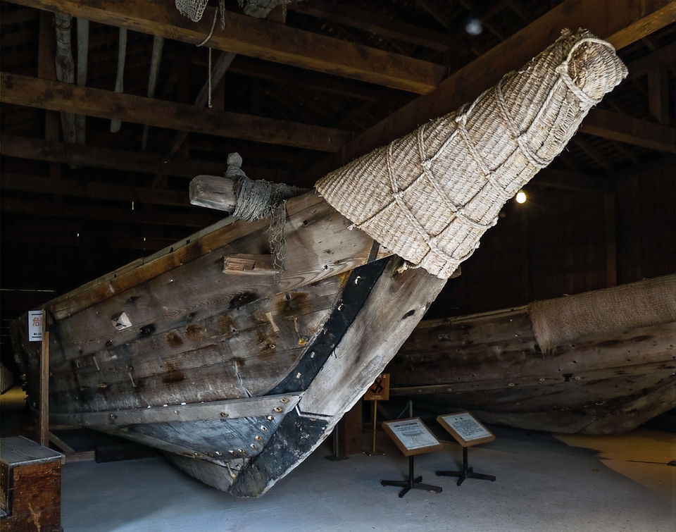
Model of a KENTOSHI ship (8th and 9th century). At full size, typical 30m bow to stern, carried a maximum of 600 people. Groups of four ships made it across the East China Sea on one voyage. (Kyushu National Museum)

Kyushu National Museum.

Kyushu National Museum. Japan's the public buildings in general, are spacious, clean and a pleasure to visit.

Smoking culture was popular in mid 16th century Europe. Cheap, brittle, low-fired pipes broke easily. The large amount of pipe fragments found in DEJIMA (the Dutch trading post at Nagasaki) shows the popularity of smoking amongst the Dutch traders. (Kyushu National Museum)
Glass hairpins (likely made in China), popular accessories among woman in Nagasaki, including prostitutes. At the time, prostitutes were the only women to enter the Chinese quarters in Nagasaki. (Kyushu National Museum).

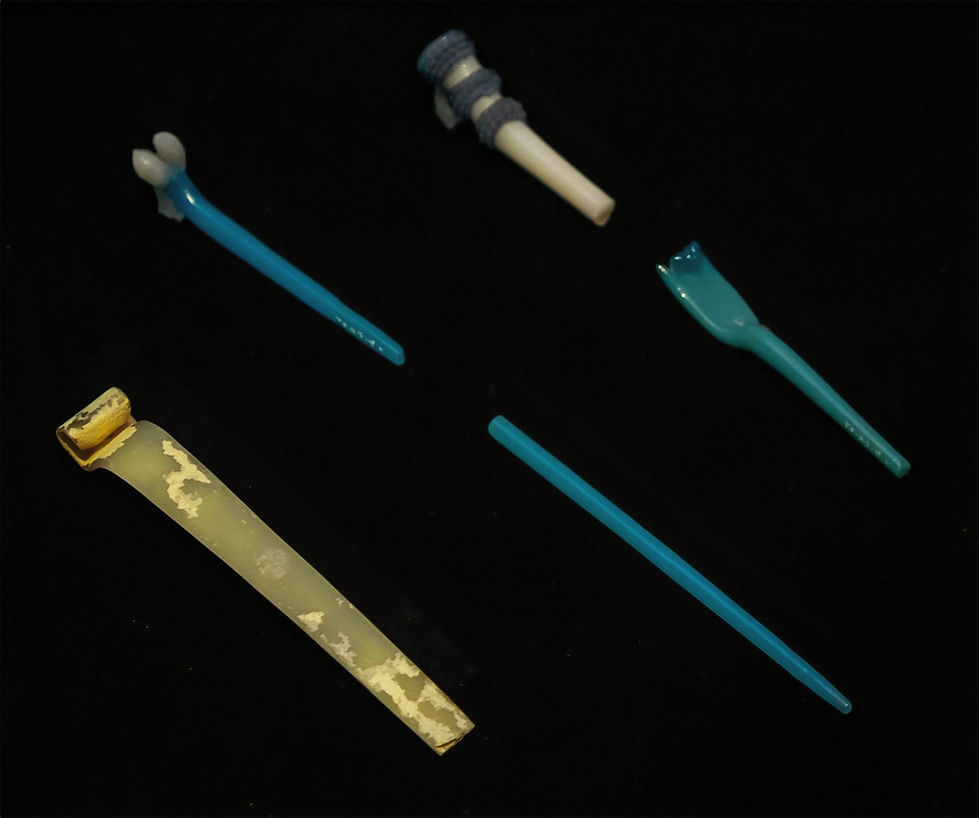
Dutch medical equipment. 19th century. Made from iron and brass, some plated with silver or tin to prevent rusting. Dejima trading Post. Kyushu National Museum.

NAGASAKI DEJIMA. Dejima was built in Nagasaki in 1636 to confine the Portuguese and stop the spread of christianity. With the the expulsion of the Portuguese, the Dutch trading post in Hirado (an island near Nagasaki) moved to Dejima. For the next 218 years, Dejima was the centre for the introduction of Western science, goods helping the modernization of Japan. The role of Dejima island ended in 1859 with the end of sakoku. On the map of Nagasaki harbour, the section highlighted in red is Dejima and the section in green the Chinese quarters. (Kyushu National Museum)


Dejima was a small artificial island, not larger than 1.5 ha's. Dejima was surrounded by a 2.7m earthen wall. The Dutchmen usually had Indonesian servants. Notable scholars include Carl Peter Thunberg, born in Sweden, published books on Japanese flora and fauna. Philipp F. von Siebold, born in Germany, established the Narutaki School of Western Medicine in Nagasaki. (Dejima Museum, Nagasaki)

Late 16th century fine Chinese (Jingdezhen) porcelain ware was imported into Europe, followed in the middle of 17th century by Arita (near Nagasaki) porcelain. Fascination with oriental porcelain in Europe, spread the production of porcelain in Europe. Copperplates were used to press lithograp on the surface of porcelain vessels; this made it possible to decorate large number of items. European ceramics imported through Dejima became sought after in Edo-period Japan. Examples are Maastricht pottery, Royal Tichelaar Makkum (mostly hand painted), Delfts Blauw. (Dejima Museum, Nagasaki)

Dejima Museum, Nagasaki.

During the Edo-period copper from Japanese mines was refined and cast in smelting plants in Osaka. Most copper was refined at the Sumitomo Copper Refinery Osaka. Each copper bar was about 23cm and 300gr. Export copper was sent to Dejima or the Shinchi warehouses built for China. and then shipped to Europe and China. (Dejima Museum, Nagasaki). From the origins of Sumitomo Copper, more than 400 years ago, SUMITOMO CORPORATION rose. I worked for and with Sumitomo as an employee and consultant for 20 years and remember well the first two business rules we followed: 1. No trust, no business. 2. No value, no profit.

Copper weighing and quality control in Dejima. All Dutch residents of Dejima were employees of the Dutch East India Company (until 1799) From June to November when Dutch ships anchored in Nagasaki Harbour, the ship captains took up lodgings on Dejima. (Dejima Museum, Nagasaki)

This the guest/entertaining dining room in the Chief Factors quarters. About 15 Dutchmen were on Dejima, including Chief Factor (Opperhoofd), Deputy Factor (Tweede Persoon), Warehouse Foreman (Pakhuis Meester), Bookkeeper (Boekhouder), Physician (Meester), Cook (Bottelier), and Carpenter (Timmerman). They were not allowed to bring their wives to Japan. Servants (Indonesian) and Africans also worked on Dejima. (Dejima Museum Nagasaki).

A model of the Dutch ship "FRIESLAND". (Dejima Museum Nagasaki).

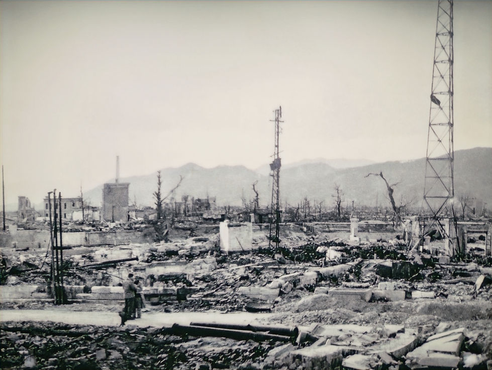
NAGASAKI Harbour today, near the city centre. Dejima is not far from here. The hypocenter of the nuclear bomb dropped in August 1945 is not far from the left of the of the photograph. Photograph taken from Mount INASA.

Nagasaki before the bombing. Photograph taken by the US Army August 7, 1945. The hypocenter is in the centre of the photograph. (Nagasaki Atomic Bomb Museum).

Nagasaki Station before the bombing. (Nagasaki Atomic Bomb Museum).

On August 9, 11.02AM the atomic bomb exploded. "KIYO NO ARASHI" (Storm Over Nagasaki), a painting by Noritaka Fukami. Mr Fukami as born in Pyongyang, September 20 1919, and graduated from Kagoshima Commercial Highschool. As a student he won the All-Japan Tourism Poster contest and his work was later exhibited in the US at the Boston Museum of Art. On August 9 he was working at the Defense Headquarters in Nagasaki. The bomb exploded 4.6km away. In 1946 he painted a scroll about the atomic bombing. In 1949 he was employed as a teacher in Kumamoto, where he designed the highschool emblem. On July 2, 1951, suffering from radiation sickness Mr Fukami takes his own life in the mountains of Yumae Mura. He was 31 years old. (Nagasaki Atomic Bomb Museum).

Preparation of the bomb ("Fat Man") on Tinian Island. The explosion of 21 kilotonnes TNT destroyed 44% of Nagasaki, killed 73,884 people (by the end of December 1945) and injured 74,909 people. (Nagasaki Atomic Bomb Museum and Wikipedia).
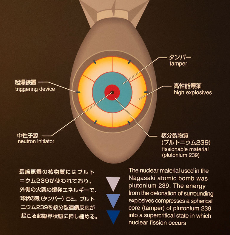
The breakdown of the energy released: the Blast 50%, Radiation 15%, Heat rays 35%. (Nagasaki Atomic Bomb Museum).

Transporting the Fat Man to the loading pit at the airstrip on Tinian Island. Tinian Island is one of three principal islands of the Northern Mariana Islands and are part of the US. (Nagasaki Atomic Bomb Museum).
Maneuvering the Fat Man over the loading pit. (Nagasaki Atomic Bomb museum).


The Fat Man is being loaded in the B29 "BOCKSCAR" at the Tinian airstrip. The Bockscar was piloted by Major Charles W. Sweeney on August 9. Mr Sweeney retired as Major-General and passed away July 2004. (Nagasaki Atomic Bomb Museum, Wikipedia)

A wall clock used in a house 2.8km South from the hypocenter. It stopped at the time of the explosion 11.02AM. (Nagasaki Atomic Bomb Museum).

View from the teahouse window to the hypocenter park entrance, where we had home made refreshment and tea.

Driving from Nagasaki to Beppu, one passes Mount ASO an active volcano. The caldera is amongst the worlds largest. The no-entry zone around the crater was lifted on July 2025 and allowed for viewing for the first time in 15 years.

Mt. Neko (1,408m), one of the five peaks of Aso, near our accommodation in Takamori. According to legend, Mt. Neko, the youngest of the five peaks of Aso, piled up rocks with the help of an ogre in an attempt to become the tallest mountain, but incurred the wrath of Aso Daimyojin, who smacked him repeatedly, leaving his head jagged.

A field near Takamori, not far from Aso.

On the Camellia Ferry from Hakata (Fukuoka) to Busan, South Korea.

Gamcheon Cultural Village in Busan. Steps to a small tea/coffee and ice-creamery. Colours everywhere and nice murals.

Gamcheon, Busan. Busan is the most important port in South Korea.

Gamcheon, Busan.

Gamcheon is part of the painful history of Busan. Refugees settled in Gamcheon Village during the Korean War and cultivated the mountainous region to make a living. In 2009, students, artists, and residents decorated the village as a part of the Village Art Project, and the town grew into an attraction of Busan since then.

The mall to Haeundae Beach. The beach is one of Korea’s popular summer destinations, attracting over 10 million visitors every season.

HIROSHIMA. Our last stop during our trip. Hiroshima is a very pleasant open city with wide streets. Our hotel "The Knot" is on the right. This crossing is not far from the hypocenter of the atomic bomb.

This small cluster of decideous trees, half a block from our hotel and not far from the hypocenter, survived the bombing.

Hiroshima before the atomic bomb. The suburb across the river is where today's Peace Memorial Park is located. The hypocenter is close to the spot where the picture was taken. The Nagasaki bomb "Fat Man" was bigger than the Hiroshima bomb "Little Boy" (21-22 Kilotons vs 15-16 kilotons tnt). The damage caused was influenced greatly by topography: the Hiroshima flat terrain as seen above allowed for widespread devastation. In Nagasaki, the city's hilly geography contained the blast.

Genbaku Dome, Atomic Bomb Dome or A-Bomb Dome before the bombing. The dome was constructed in 1915 as the Hiroshima Prefectural Industrial Promotion Hall, designed by the Czech architect Jan Letzel. The dome is located near the hypocenter.

At 8.15AM, August 6, the atomic bomb released by the "ENOLA GAY" B29 detonated above Hiroshima. "It was red, perhaps a sort of blackish red-orange. In any case, it was vivid, intense colour I'd never seen before." (Atomic Bomb Testament. The photograph is taken 6.5km from the hypocenter, Mikumarikyo Gorge, by Seiso Yamada. Collection of The Chugoku Shimbun. Peace Memorial Museum).

In the first minutes 66,000 to 80,000 were immediately dead. Many vaporized by temperature up to 4,000 degrees C or by the blast wave. In the first four days the death toll has reached 120,000. By the end of 1945 the death toll reached 140,000. Many died by the severe burns and by high doses of radiation. (Peace Memorial Museum).
Five-year total estimates suggest the death toll reached 200,000 by 1950. As of August 2025, the modern victim registry has the combined official victim registry of both Nagasaki and Hiroshima exceeding 540,000 victims.

Genbaku Dome. (Peace Memorial Museum)

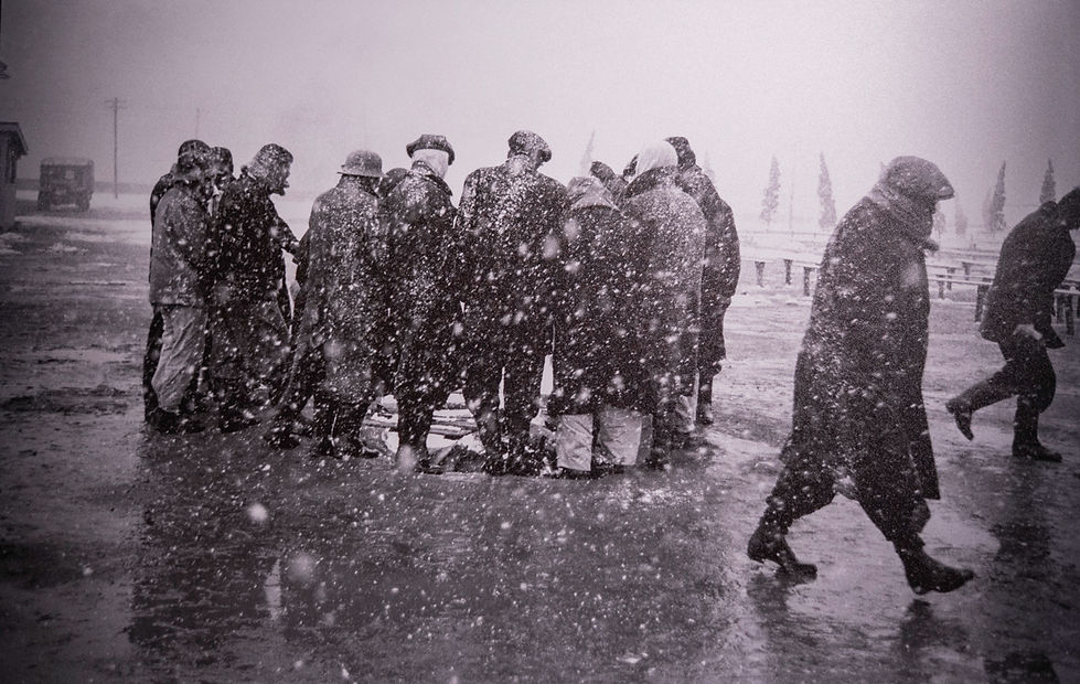
Around 11AM, August 6, 2,270m from the hypocenter, the Miyuki Bridge was covered with severely burned people. "I held the camera up, but I couldn't snap the shutter. Finally, after about 20 minutes of hesitation, I took my first picture". (Photograph by Yoshito Matsushige; Collection of The Chugoku Shimbun. Memorial Peace Museum).

Miyuki Bridge. Photograph by Yoshito Matsushige. (Memorial Peace Museum)

After 4PM. August 6, a Policeman writing Disaster Certificates, 2,400m from the hypocenter. (Photograph by Yoshito Matsushige Collection of the Chugoku Shimbun. Memorial Peace Museum).

August 7. Girl Student suffering from burns. First Municipal Elementary School. (Photograph by Army Marine Headquarters. Shogo Nagaoka Collection. Memorial Peace Museum).

Corpses Floating on the River. Early morning August 7, 1,300m from the hypocenter upstream from Yokogawa Bridge. (Drawn by Kenichi Nakano. Peace Memorial Museum).

August 6, 260m from hypocenter. Thirsty woman catching radioactive black rain. (Memorial Peace Museum).

Tsutomu Saeki (33) was exposed to the bombing at Chugoku Regional Military Headquarters, 790m from the hypocenter. He died almost instantly. His wife Tazuko (then 28) was in the last month of pregnancy and 4 days after Tsutomu's death his daughter Hiroko was born. Left with her sons, ages 6 and 4 and the newborn Hiroko, Tazuko restarted her family's soba restaurant and raised her children. (Memorial Peace Museu)

Boarding a train, departing from Hiroshima Station, September 1945. After the surrender, soldiers stationed in Hiroshima and survived were demobilized and returned home. Many Koreans who had been living in Hiroshima for various reason returned to their home country (Memorial Peace Museum).
Living with improperly functioning bodies. Many survivors lost their jobs and struggled through a hand to mouth existence. Facing discrimination and the false assumption that A-bomb diseases were contagious. Even when they has a job, many tired easily and had to take frequent breaks. It was said they had "Bura bura byo" (idler's disease) and were treated with cold disdain. (Memorial Peace Museum)

Hiroshima, May 12 1952, looking West down Peace Boulevard, near the future Memorial Peace Museum and Memorial Peace Park. Hiroshima is historically a military city. The first Sino-Japanese war (1894-1895) made Hiroshima a military base. The Imperial Headquarters (primary command centre) moved from Tokyo and established in Hiroshima, as did the Meiji Emperor. Each time Japan took military action troops gathered in Hiroshima. The Manchurian Incident (1931), escalated to a full-scale war with China in 1937, and soldiers and materiel were dispatched from Hiroshima to battlefields in China and Korea and leading to the "Nanjing Massacre". In 1941 Japan started the Pacific War and the entire Hiroshima was caught up in the war effort. As the tide turned against Japan, the US launched intense air raids against Japan.

THE INHUMANITY OF NUCLEAR BOMBS. Sometimes arguments are made that, there is not much difference in the human suffering if one considers conventional bombs. The death toll after the firebombing of Tokyo on March 9 and 10 1945 reached an estimated 100,000 people, mostly civilians. This single raid known as Operation Meeting House, left approx. 1 million people homeless. The photograph above shows the devastation. In Dresden, Germany, between 22,700 and 25,000 died during the bombing between February 13 and 15, 1945. Nuclear bomb survivors and others have long pointed to the inhumanity of nuclear weapons. The Conference On The Humanitarian Impact Of Nuclear Weapons (Oslo, March 2013) presented reports on the medical effects of nuclear bombs and the experiences of the survivors. Many countries confirmed that they lack any ability to respond effectively to nuclear attack. In April 2013. a "Joint Statement on the Humanitarian Impact of Nuclear Weapons" was introduced by South Africa and endorsed by 80 countries. It clearly stated that nuclear weapons must never be used again, under any circumstances, and the only way to ensure that is to eliminate them. (Memorial Peace Museum).

Hiroshima Memorial Peace Park today.
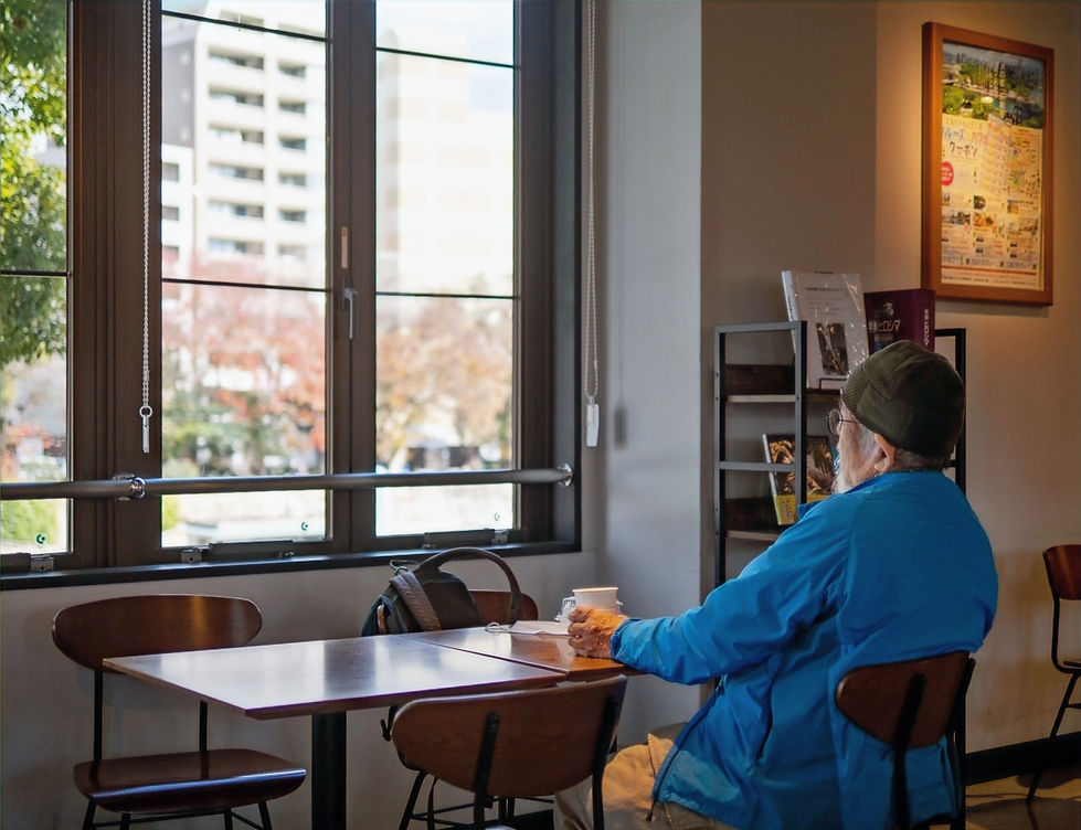
A visitor to the Memorial Peace Park contemplating in the Peace Park's cafe.

The Memorial Park has many visitors, in particular students; it is an important learning centre.

Hiroshima today, not far from the hypocenter.

The intersection after the bridge on the Peace Boulevard, close to the Memorial Peace Museum.

Enjoying a meal in Fukuoka, Kyushu. A great trip to Korea and Japan!

Tasmania
December 2024

An early morning departure; leaving on a large ship is always exciting, and so it was this time. On our way to beautiful Tasmania. We have visited this large island several times before and hope to experience again its stunning nature and parks.

The ferry departs from Geelong, Victoria. The vessel is due to be replaced with a newly built ship (built in Finland, the same as our vessel), however there is a delay with making the Devonport port facilities suitable for the new ship. Therefor, we need to wait a while before the new ferry is crossing the Bass Strait. The ship we were sailing, the SPIRIT OF TASMANIA I, is very comfortable and has very good facilities. The day we sailed the weather and sea was very calm.

There was quite a bit of rain over the Bass Straight, although we did not sail through any rain. The voyage takes about 10 hours, depending on the weather and seas. The Spirit Of Tasmania I was built in 1998 by Kvaerner Masa-Yards at Turku New Shipyard in Finland and is powered by four Wärtsilä 16ZA40S diesel engines.

Setting up camp, near Ouse, central Tasmania. Sunny days, but the wind quite blustery, beaufort 7. From there Brenda, Phil, Lumen and I travelled to the beautiful parks. We also stayed a few days in motels when we strayed too far from camp. A very pleasant time indeed.

The Styx Tall Trees Conservation Area - with the Eucalyptus regnans, the giant ash, which give the reserve its name. Numerous trees measure over 90 metres, make them among the largest and tallest eucalypts. The Styx play a significant role in Tasmania's controversial environmental history. After a bitter campaign the Styx was added to the forest reserve system in 2013.

The undergrowth is dense; mosses, ferns and rich birdlife. On the day of our visit there was no wind and the forest was very quiet, except for cawing of the ravens in the tall canopies.

Lake Dobson, part of Mount Field national Park, is a small glacial lake and is colourful in autumn when the deciduous beech (Nothofagus gunnii) turns. We walked around the lake; a wonderful experience; there were very few people on the day of our visit and so many beautiful plants to see.

Lake Dobson. Flowers in the green.

Lake Dobson. Lichen, a pure cream and white and delicately beautiful.

Lake Dobson alpine lake vegetation.

Ola from Lake Dobson.

Lake St Clair, a cold, blustery and rainy day on our visit. Lake St Clair or "Leeawuleena" is a natural freshwater lake; it forms the southern end of the Cradle Mountain-Lake St Clair National Park. It has an area of 45 square kilometres, and a maximum depth of 215 metres, making it Australia's deepest lake. The lake marks the start of the River Derwent.

Hells Gates marks the entrance to Macquarie Harbour from the Southern Ocean. Captain James Kelly (a sealer and harbourmaster) came upon Macquarie Harbour and its Huon Pine in 1815 while circumnavigating Tasmania in search of resources. Kelly made this trip in a whale boat with 4 oarsmen discovering huon pine in all the fresh water rivers from the Huon river in the south east coast round the south coast and as high up the west coast as the Pieman River all containing forests of the pine. The greatest amount found was around the shores of Macquarie harbour and up the Gordon river and all its tributaries. Kelly named Sarah Island for the wife of merchant Thomas Birch, who financed his voyage. News of Kelly's discovery prompted L. Governor Sorrell to select Macquarie Harbour for a penal settlement. Sarah Island became this settlement. The purpose of the settlement was to incarcerate the toughest of the convicts barracked in Hobart and to set them to work harvesting the valuable Huon Pine from the nearby rivers.

Hells Gates. The entrance for convicts from Hobart destined to Sarah Island. The passage itself already treacherous. At the top of the map, left hand corner one can see the rock breakwater at Hells Gate. It is 1.2 kilometers long; this breakwater was constructed to channelize the flow through Hells Gate, the mouth of Macquarie Harbour; and it was constructed with labour from the penal colony; rock by rock. Amazing. The breakwater is still there!

Macquarie Harbour. It was all about Huon Pine. Small Sarah Island can be seen on the lower West side of Macquarie Harbour in the highlighted area.

Our visit to Sarah Island. The day was cold, with frequent rain squalls. In winter it's with sleet and wet snow.

Ruins of the solitary confinement building. The bricks were made on Sarah Island and also exported to Port Arthur (near Hobart) for the construction of the penal colony there.

Ruins of the prison warden's house. A nice elevated view.

Banks of the Gordon River, Macquarie harbour. Upon arrival on Sarah Island, the convicts were tasked with clearing the island of its vegetation. Working in chain gangs, they then became Tasmania's first piners. Huon pine and other timbers were cut from forests near the streams and rivers of Macquarie Harbour. The forest was dense and most huon pines were cut from the banks of the waterways as access was (somewhat) easier. As one can see in the photograph, the banks often steep and treacherous. Initially huon pine was shipped to Hobart, but the difficulty of transport (due to frequent poor weather) required a change of plan. Within a decade, authorities had transformed the island into an industrial penal village. Under the guidance of master shipwrights (even from the East coast of America, lured by the unique and special huon pine), over 100 vessels of varying sizes were built. It was hard, cold, wet labour, but the convicts that survived departed as skilled tradesmen. In 1833, after 12 short brutal but productive years, the settlement and its shipyards closed due to access difficulties, frequent escapes and the opening of Port Arthur. Shortly after the island became a base for local piners harvesting in the area.
Huon Pine (Lagarostrobos frankilinii). A podocarp conifer, endemic to Tasmania is found only in rainforests. To survive they need to tap in a permanent water supply, thriving in dense forest close to streams and rivers; in this way Huon Pines are somewhat protected from the frequent destructive forest fires. Huon Pines are contenders for being the oldest living plants; one clonal grove may be 10,000 years old and individual stems have been dated 3,400 years. It has a very slow growth rate of about 0.3 — 2 mm per year, taking 1000 years to reach a height of 30 m and a diameter of 1 metre. The timber is truly unique and valuable: it has a very high oil content (methyl eugenol), which makes it impervious to insects, marine borers and resists wood rot (unlike the European and American oak built ships which were very susceptible to marine borers; only in the late 19th Century the introduction of iron-clad ships, signaled a shift towards metal shipbuilding from oak built vessels). The high oil content of Huon Pine also means the timber can be bent, shaped, worked and sculpted without splitting and finishes to a superb, fine lustre. Fallen submerged logs are preserved, without affecting the quality. Once harvested unsparingly, they are now a protected species. 85% of remaining Huon Pine forests are conserved in National Parks while 15% is managed by Forestry Tasmania for salvage. Forestry Tasmania controls and surveys all salvage/harvest sites and only a few sawmills are licensed to process logs. The Huon Valley, along with its local government authority, several towns, the Huon River, and the Huon Pine, were named after Jean-Michel Huon de Kermadec, a French Navy officer and explorer who visited Tasmania as part of Bruni d'Entrecasteaux's expedition in the 1790s. (In the table below, the Ginko is a gymnosperm, however is not a conifer. See the travel section of Shikoku)


The Tahune River - Huon Valley, Southern Tasmania. A natural habitat for huon pine and other endemic conifers and broadleaved plants. The water seems black, however it is clear, tinted by rich organic matter.

Huon pine has distinctive, feathery foliage characterized by tiny, scale-like leaves. These small scales give the tree a unique, almost moss-like appearance and contribute to the overall delicate, drooping habit, especially in shady areas, further enhancing the feathery appearance. Huon pines reproduce vegetatively by layering or root suckering, as well as by tiny, pin-head sized male and female cones in spring, sitting at the end of the scale-like leaves.

A young huon pine, near the bank of the Tahune River

A trunk of a huon pine near the bank of the Tahune River. Considering the size, this tree is a 1,000 years or so old. Generations come and go, a continent taken and settled, and this tree already here and well established. Sculptor Anne Ferguson aptly described the huon pine: "The quality of huon pine is that it is forever".

A young King Billy Pine (Athrotaxis selaginoides), near the Tahune river bank. A cupressaceae, also at times named "Australian Cedar". The King Billy Pine was named in honor of William Lanne (c.1836 – 3 March 1869), also spelt William Lanné and known as King Billy or William Laney, was an Aboriginal Tasmanian man. The King Billy pine is endemic to Tasmania, grows in rainforest, normally at the higher altitudes It can grow up to 40m; the King Billy is now a protected species that was very sought after for boat building and now for musical instruments.

More frequent forest fires has made the King Billy an endangered species. King Billy pines have been known to grow to 1,800+ years. Their rot-resisting qualities are not as phenomenal as Huon, but they can be successfully stockpiled for perhaps hundreds of years, an ability unheard-of in most other timbers. Several decades of salvage and careful husbanding of the logs has created a stockpile at Tasmania Special Timbers mill; probably the world’s only suppliers of sawlog King Billy pine. All of the resource – including the hundreds of fire-killed skeletons dotting the western ranges – is now fully protected.

The King Billy Pine was named in honor of William Lanne by early European settlers in Tasmania. They referred to him as "King Billy" due to his status as a tribal leader. From 1859, Lanne found work as a whaler in the Tasmanian whaling and sealing industry. Lanne worked on many whaling ships, including the Aladdin, which sailed under the well-known whaler Captain McArthur, the Jane, the Runnymede and the Sapphire. The latter worked the waters of the Southern, Indian and Pacific Oceans. Lanne had a good-humoured personality, was well-spoken and admired among the Hobart community. He is recorded as advocating for improving the living arrangements of the women at Oyster Cove Settlement by writing to colonial officials in 1864. He formed a relationship with Truganini and was generally regarded as being her spouse during this period. Truganini, a famous indigenous woman who, as a teenage girl, was held for sexual purposes by British sawyers. In 1868, Lanne was a guest of honour at the Hobart Regatta, where he met the Duke of Edinburgh. It is here that he was also introduced by the governor as the "King of the Tasmanians". (Photo courtesy Tasmania Library archive)

The Celerytop Pine (Phyllocladus aspeniifolius), a podocarp, is endemic to Tasmania and is the most widespread and abundant conifer in Tasmania. It is a common constituent of cool temperate rainforest vegetation types in Tasmania. The largest Celerytop Pine are found in wet sclerophyll forests with a canopy of Eucalyptus spp, and can be up to 800 years old. They grow on acidic soils derived from dolerite, granite or quartzite, that is well drained and may be on boulder or scree slopes, in high rainfall areas with no marked periods of drought. They are less shade tolerant than their fellow rainforest species, relying on a higher fire frequency for regeneration in these areas and regenerate freely in burnt forests. The wood is hard and strong with little shrinkage, bends and works well, and is very durable. The beautiful wood is used for railway sleepers, flooring, ship masts, furniture, and cabinet work.

A mature tree near the Tahune river; a large portion of Celerytop Pine is located in protected forests in Tasmania or in forests open to logging with management that allows for the persistence of native trees. The IUCN, lists the species as “Least Concern”, indicating its persistent abundance in Tasmania.

Nothofagus cunninghamii, commonly known as myrtle beech or Tasmanian myrtle, is an evergreen and the dominant species of cool temperate rainforests in Tasmania and Southern Victoria. It has low fire resistance and grows best in partial shade conditions. Height range from trees of up to 50 meters in protected rainforest valleys to low-growing alpine shrubs less than 1 m tall in exposed conditions. Nothofagus means “false beech” . There are 43 species of Nothofagus, with only three occurring in Australia: N. cunninghamii, gunnii, and moorei. Nothofagus gunnii is a deciduous beech endemic to Tasmania that grows in low-fire, alpine regions. Nothofagus moorei, or Antarctic beech, is another cool temperate rainforest evergreen found in patches in New South Wales and Southern Queensland. (Nothofagus spp., also known as the southern beeches, is a genus of 43 species of trees and shrubs native to the Southern Hemisphere, found across southern South America (Chile, Argentina) and east and southeast Australia, New Zealand, New Guinea, and New Caledonia).

Eucryphia lucida, the leatherwood, is a species of tree or large shrub endemic to forests of western Tasmania, Australia. Ranging from 2–10 m in height, it can sometimes grow to 25 m in favourable conditions. It is widespread and common in moister forests in Tasmania, occurring mainly across the western parts of the state, from the northwest in such places as the Tarkine and through the South West Wilderness. It grows as an understorey plant and prefers wetter climates of 1500–2500 mm annual rainfall. Their white flowers produce nectar that attracts honeybees. Leatherwood honey is rare and has a unique and strong taste. The leatherwood tree only blooms for six to eight weeks out of the year. Many beekeepers camp in the Tasmanian forests during the honey harvesting season. This gives the beekeepers the best chance to collect leatherwood honey.
Sources Tasmania trip: Australian National Herbarium, The Gymnosperm Database, Wikipedia, Tasmania National Parks, Tasmanian Special Timbers, Tasmania Library Archives, personal files.

Shikoku
October 2024

Shikoku, Japan. We had a wonderful drive and walk 15 day visit to rural Japan. The first stop Itano-Gun (Tokushima Town). Situated at the mouth of the Yoshino river, from the camera's position pointing Northeast.

Mount Bizan, Cafe and restaurant with a view to Tokushima.

One of the many maples on our way to Hyakken Falls, Tokushima Prefecture.

Hyakken Falls. There were no people. Timeless, patience, respect and achievement.

A field with a feeding butterfly, near the Kashihara Rice Terraces. The rice terraces are located 700 metres above sea level.

On a side road near the Kashihara Rice Terraces, Tokushima Prefecture. Lumen had fun recording a video for Laoise, Nicholas and Matilda.

Ochiai Village along the Yoshino River in the Iya Valley. Unique homes and stone walls built between the mid-Edo period and the Meiji period on a steep hillside. Standing on the walkway of the historical Samurai house - late 17th century.

In Saijo, Maegami-ji Temple (No 64). One of the eighty eight temples of the Shikoku Pilgrimage. Saijo is the "Spring Water Capital of Japan". Water from the Kamo River permeates into the surrounding land and bubbles up in numerous places; at one time Asahi Breweries made their beer in this town. Now there are mainly small craft breweries.

Maegami-ji temple grounds - Advisor to Elders.

From Saijo, a beautiful relaxed hike in Eastern Ehime. Mount Tsurugi, 1,955 metres.

Mount Tsurugi. Autumn colours are starting to be displayed at the higher altitudes. Ground cover bamboo is widespread.

Seedlings, undergrowth near Oku-Iya Kazurabashi (vine) bridges.

Omogo Gorge ("Omogokei"). Located at the foot of Mount Ishizuchi. This Mount is 1,982 meters. The Gorge is 10 kilometres long. Mount Ishizuchi is the highest mountain in Western Japan.

Omogo Gorge. Cristal waters. Stay and rest awhile.

Omogo Gorge, facing the cliff face from the opposite side of the river.

A bridge over Omogo Gorge river.

Matsuyama, Ishiteji Temple house. Temple 51 on the Shikoku pilgrimage.

73% of Japan is mountains and 67% is forested. In the lowlands forests are mostly gone. Much of the forested areas are not natural, but cut and planted with lumber trees. Biodiversity is somewhat lacking in the forests. 1% of Japan forests can be considered primeval. Forests of Kyushu, Shikoku and halfway up the coast of Honshu are home to Pinaceae, Cupressaceae and Southeast Asia broadleaf evergreen trees; the beech family (Fagaceae), laurels (Lauraceae), the asterids (Theaceae) and decidious maples (Sapindaceae). These include Quercus (oak), Lithocarpus (stone-oak), Castanopsis (chinquapin), Cinnamomum (camphor), Machitus (bay) and Camellia (tea, the earliest fossil record of Camellia are the leaves of C. abensis from the early opening of the Japan sea). In the low mountains lives the elegant Pinus thurbergii (Japanese black pine). A revered garden and bonsai tree and is wide spread along coastal stretches. The Japanese cedar (Cryptomeria japonica) "Sugi", both beloved and not loved, is the national tree of Japan. An evergreen conifer, some are 50 to 70m tall with a girth of 10m or more, which is amazing for typhoon swept Japan. A close relative to to redwoods and sequoias and it is an important timber tree. After WWII a big program to re-forest the mountainsides was initiated. Both Sugi and "Hinoki" conifer (Chamarcyparis obtusa) were planted; the negative effect of pollen season (late winter to early spring) has millions of people suffer for weeks of hay-fever from the clouds of pollen from the mountains. The timbers are however too important for Japan and pollen releases will continue each year. The Hinoki have a special place in Japan, for its revered wood and fragrant essential oils. (Sources: Botanyboy Plant Encyclopedia, Wikipedia and files).

Conifers are classed as Gymnosperms because they have “naked seeds” which are not surrounded by an ovary. Gymno comes from the Greek for “naked”. Conifers have leaves that are needle-like or scale-like. The word “Conifer” means cone-bearing. They bear pollen cones and seed cones, not flowers and fruit. The male and female cones are borne on the same tree. The male cones are usually found on the bottom of trees and the female cones are usually found at the tops. Pine, Spruce, Cedar and Cypress are softwoods used in construction and furniture manufacture. Also known as the Maidenhair Tree, the Ginkgo is a Gymnosperm but is strictly not a Conifer. It has catkin-like pollen cones like a Conifer but does not produce seed cones. Its seeds develop into round green fruits on the end of stalks. The fertilisation process involves motile sperm, a feature of Mosses, Liverworts and Ferns. Hence it is in a botanical class of its own and is often referred to as a “living fossil”. The Ginkgo, is the only surviving member of a family, which has existed since the Permian period 270 million years ago and the only surviving member of the Ginkgo genus. (Sources: Treeguideuk.co.uk, Wikepedia, Farmpark.org)

Ginko biloba. Near Matsuyama castle. This tree is not uncommon in Shikoku.

Near Nishinooka village. Our Kondoke inn Ryokan host drove us up the mountain and we made our way up to the splendid water falls of the Kompinaje mountain.

Bridge in Toon, Nishinooka village. Some rain during the day. We had a very rewarding day.

Falls on Kompinaje mountain. Wonder about dense growth on steep inclines, light and the ever sound of cascading water.

A prepared path up the mountain. These paths are part of the pilgrimage trail and cross the entire Shikoku.

Toon, Nishinooka village. Bamboo and tea.

Water feature in Nishinooka village, near Joruri-ji temple.

Pilgrim path. Namekawa waterway in the valley near Nishinooka village. Pilgrims left many small river stone shrines.

Otoyo, in Kochi prefecture. Small building near the temple, adjacent the 3,000 year old giant cedar tree (Cryptomeria japonica), "Sugi no Osugo".

"Sugi no Osuge"- 3,000 years. It may look like two trees, however the two trunks are connected at the root, hence its nickname, "the wedded cedar". Typhoons have damaged the tree and to protect the tree ceramic tiles and copper plating is attached to the damaged bark to protect from further damage and contamination.

Takamatsu. Ritsurin garden. Maintained for 400 years.

Miguel.

Visitors to the garden and teahouse.

Garden tea house. Beautiful sugi and hinoki woodwork, standing the test of time.

Cook and bbq area for pilgrims and overnight campers. Mt Kajigomori.

Mount Kajigamori.

A pilgrim path. We did not walk all path's and made good use of our roomy Daihatsu cube car. We enjoyed so much nature, tranquility and what Shikoku mountains made us experience.

Tierra del Fuego
April 2012
.jpg)
On our way to the Uttermost Part of the Earth, reflecting by a still pond with dropped leaves from winter, in early spring (Amsterdam). Highly recommended to read: UTTERMOST Part Of The EARTH by E. Lucas Bridges – A History Of Terra Del Fuego And The Fuegians. Buenos Aires, August 1947. A personally fitting dedication by Mr E. Lucas Bridges:
TO MY DEAR WIFE -
And o’er the hills, and far away
Beyond their utmost purple rim,
Beyond the night, across the day,
Through all the world she followed him
TENNYSON

USHUAIA Port. From where we departed for our sojourn through the Terra Del Fuego Channels. The port has few ships – and one has a vista to the Beagle Channel.
From WIKIPEDIA: The channel was named after the ship HMS Beagle during its first hydrographic survey of the coasts of the southern part of South America which lasted from 1826 to 1830. During that expedition, under the overall command of Commander Phillip Parker King, the Beagle's captain Pringle Stokes committed suicide and was replaced by captain Robert FitzRoy. The ship continued the survey in the second voyage of Beagle under the command of captain FitzRoy, who took Charles Darwin along as a self-funding supernumerary, giving him opportunities as an amateur naturalist. Darwin had his first sight of glaciers when they reached the channel on 29 January 1833, and wrote in his field notebook "It is scarcely possible to imagine anything more beautiful than the beryl-like blue of these glaciers, and especially as contrasted with the dead white of the upper expanse of snow."

Taking a 360 degree view, it always rains somewhere. This is the home of the Yamana people, decimated and now absent from these lands, through pestilence and disease, brought by European settlers.

Today pathways are made and passage is easy – Cape Horn, a 'Graveyard of ships' is an apt name; the coastal line is marred with too many sunken ships. Thinking of the absolute terror experienced by its crews and loved ones left behind… The Cape Horn monument for all those perished.

From our comfortable small cruise liner, it was only a short trip to the Cape. We are privileged people.

Early settlers built homes and brought sheep and tame the land. Not Terra Del Fuego, most, if not all settlements were proven indeed foolhardy in ignoring the extreme and severe conditions.

Photograph: Courtesy Ushuaia Museum. 1580 – 1600 First European visitors, Samiento de Gamboa and others. The YAMANA, a sea-going people living in the channels. Living on canoes, men hunting seals from the prow and the women diving the icy waters for shellfish; only a layer of seal grease to protect from the cold. Only the women swam. Fires were lit in the canoes, for comfort. When not at sea, the Yamana stayed in dwellings made of evergreen beech branches. Terra Del Fuego – Land of Fires, because of so many canoes with fires.

Silence, ice in mirror like water and rising mountains. One can only be spell bound by this unique and stunning beauty.

Photograph: Courtesy Ushuaia Museum. The YAMANA, a sea-going people living in the channels. Terra Del Fuego.

Terra del Fuego Canals - light changes continuously, the sun is there, then covered by dark clouds in minutes - snow on the ranges, and not a soul present.